What's New
Bug fix...
Bug fix...
Size:
11.5 MB
Category:
Navigation
Navigation
OS:
iOS
iOS
Price:
$9.99
$9.99
Compatible:
iPhone iPad
iPhone iPad
Requirements:
Compatible with iPhone
Compatible with iPhone
Version:
1.0
1.0
Description - SeaNav US - Nautical Charts & Navigation
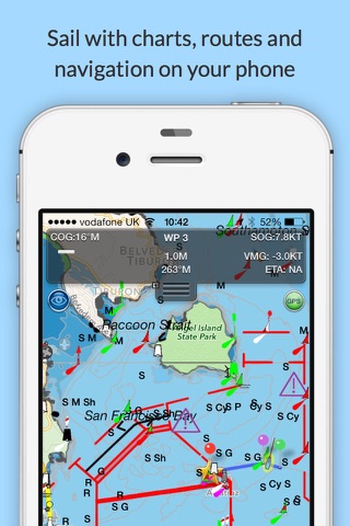
HIGHLIGHTS
.
Reliability20
and this app just for boating. found in 1 reviews
route planning and tracking with waypoints sog cog eta etc. found in 1 reviews
I use it with a Garmin GPS Bluetooth unit. found in 1 reviews
not for navigation. found in 2 reviews
turn off location services on iPad. found in 1 reviews
are tappable with bearing and distance. found in 1 reviews
1 year of free chart updates. found in 1 reviews
seamless fast panning and zooming across charts. found in 1 reviews
Use in conjunction with Boat Beacon. found in 1 reviews
includes us coastal and great lakes charts. found in 1 reviews
accurate and friendly tech support seals the deal for me. found in 4 reviews
particularly for its lack of detail upriver from Pickwick Dam. found in 1 reviews
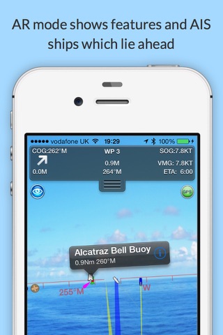
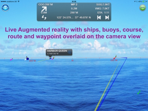
live augmented reality camera view. found in 1 reviews
Needs much improvement. found in 1 reviews
zoom in out is app took a time to load or freezes. found in 1 reviews
Charts are simple to read when the do load. found in 1 reviews
Zooming out makes the map unreadable for at least as long. found in 2 reviews
Crashed 5 times in the first 15 minutes - Yuk. found in 1 reviews
At the moment it requires you to connect to external gps. found in 2 reviews
Slow to the point of being unusable. found in 1 reviews
If you are iPhone and iPad owner,you now can download SeaNav US - Nautical Charts & Navigation for $9.99 from Apple Store. The application is supporting English language. It weighs in at only 11.5 MB to download. It is highly advisable to have the latest app version installed so that you don`t miss out on the fresh new features and improvements. The current app version 1.0 has been released on 2014-11-20. For ensuring consistency with the device you should take into account the following app compatibility information: Compatible with iPhone 3GS, iPhone 4, iPhone 4S, iPhone 5, and iPad. Requires iOS 6.0 or later. This app is optimized for iPhone 5.
Bottom Line: For more information about SeaNav US - Nautical Charts & Navigation check developer Electric Pocket`s website : http://seanavapp.com
Bottom Line: For more information about SeaNav US - Nautical Charts & Navigation check developer Electric Pocket`s website : http://seanavapp.com
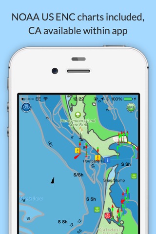
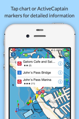
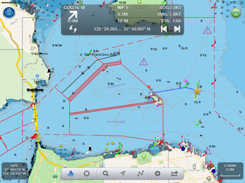
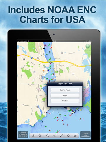
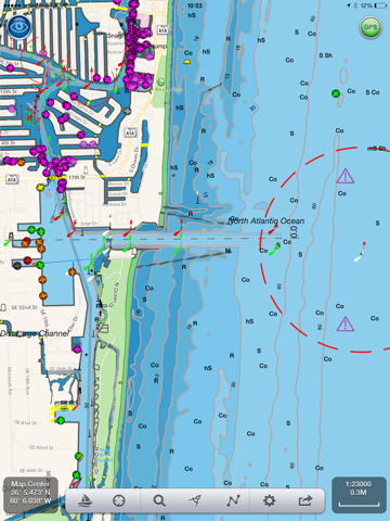
Explore, Plan and Navigate your boating trips in real time and outstanding high-resolution with the latest NOAA Digital Vector Marine charts covering the whole of the USA and Great Lakes. Route Planning and real time ...
I sail Alamitos Bay in Long Beach CA Although I have Anchorages layer OFF the chart still indicates all anchorages So many are shown that they overlap and are unreadable On my iPhone 6 Plus the chart is useless Tech support claims that the anchorages are the names of the water areas and will show even with the Anchorages layer turned OFF 30 bucks out the window as far as I m concerned Not for iPhone Brian TF
Crash calibrate seems that s all I do with this app This app is not even good for recreational boating Don t waste your time money Poor slow Pet Gear Depot
Crashed so often that I couldn t even view harbors Vey allow on my LTE iPad Mini Depth contours 0 18 18 30 and 30 600 are less than ideal I would want to navigate my boat using this app and its maps Crashed 5 times in the first 15 minutes Yuk D_Snow
I give it 5 stars because it is an intuitive app and if you do any type of weekend trip on a cabin cruiser near the major bays it s probably fine I like the fact that it pings GPS every minute when in background mode to save energy I like the intuitive interface and myriad options one can set Their tech support is great I ve been emailing them and they have done all they can to work with me and even suggesting a refund I appreciate a company like this but I did ask them to update their description to make sure people know about the Tennessee River depth contour issue I bought a competing app after I bought SeaNav and I initially considered refunding the SeaNav but I like it enough reasons to keep them both I m not a pro but I have spent a lot of my life in twin engine Chris Craft cruisers as well as little runabouts I keep laminated official marine charts and realize these apps are no substitute for charts I CANNOT RECOMMEND THIS APP FOR THE TENNESSEE RIVER particularly for its lack of detail upriver from Pickwick Dam Pickwick Lake towards Wilson Dam and lack of more detailed depth contours There are underwater stumps galore and you must stay in the channel you need to follow SeaNav does not show a route and does not label any of the obstructions even though it would probably be impossible to pinpoint them all I bought this app for the depth contours that showed up in the preview images thinking they would be on all US waterways Seems their map source does not offer those so I get only two depth contours on the Tennessee River through North Alabama 9ft and 9ft Seriously Inaccurate rendering of depth contours even in slews that are 20 feet deep it is a blue color representing 9 ft deep We do a lot of activities in our runabout in shallow slews and also a couple miles up from the mouth of the Elk River The mouth of the Elk River has channel markers but this app does not show a route through that channel The river renderings stop after you leave the main Tennessee River Elk River on Wheeler Lake forget it Shoals Creek on Wilson Lake forget it Bear Creek on Pickwick Lake forget it Good app but NO detailed depth contours for Tennessee River Flexoffset
The app is crisp and responsive on my 4th gen iPad and the AR feature was a huge help in confirming landmarks while sailing through the fog along the Monterey coast Snappy and helpful gschroder
They keep working on this app and its become much better performance is good on my iphone 5 Nice improvements SuperSaint2009
The charts draw soooooo slowly this app is virtually unusable Unusable Appkiller434
It crashes about half the time thus far Too slow and crash prone RafaU
The slightest move on the chart causes a 5 20 second wait for the map to redraw itself Zooming out makes the map unreadable for at least as long Simplifying the map only helps a little bit still too slow to use The charts are way too busy graphically speaking very hard to even find a channel with giant marker icons The only good thing is that is coordinates with boat beacon a very good app Get Navionics 1000 times better Slow to the point of being unusable Layr Layr
Will not run on my 124g iPad3 more than two minutes before crash Crash Z090
I am running this app on an iPhone 5 with iOS 7 Since purchasing I haven t been able to use the app due to it crashing every time I open it Please update your app to work with the new iOS or remove it from the App Store if you cannot support it Crashes frequently JFNeal
when you set sail to a point it crashes and then you have to start all over Adding spots should be simple but its not you should be able to tap in boat position and add your fav spot zoom in out is app took a time to load or freezes Crashes Moemoe33
It would be a great app IF it would use iPad internal gps At the moment it requires you to connect to external gps How stupid is that I used version of this software back on PC Back than I understood need of external gps Not theses days Please fix it Meantime I will stick to iSailor Needs work Sailoresa
Loads charts very slowly Should have an option to turn land detail off Charts are simple to read when the do load I would not have purchases this app if I was able to use it first There are much better navigation apps available Needs much improvement Goldi2
This app saved us last night in the fog Got home safe thanks to this excellent app Awesome New boater
App is suppose to cover all US charts yet none of the lakes in my area show up In fact none of the lakes in my state show up and we are talking some rather large bodies of water The only body of water to show up is a floodplain called little blue river which isn t even navigable lol App should correctly read only select US bodies of water not ALL U S charts Waste of 10 Navionics is much more complete Misleading Media-amp
Love the look and feel of the charts Easy to read Zoom in and out makes my onboard Raymarine software equipment a relic Use in conjunction with Boat Beacon app This will give you real time AIS Exceptional Porter
Works best on iPad 3 with cellular wifi as this iPad 3G has a GPS assisted capability whether connected or not to a cellular network IPad 2 wifi no cellular dees NOT have a GPS Satellite Receiver in them so you would need to add a GPS receiver to an iPad 2 I tried using a Verizon Hot Spot Cellular with iPad 2 and neither worked nor did Apple Maps or Google Maps There are no cellular towers in the middle of Lake Michigan so the triangulated cellular cannot function on a iPad 2 You end up sliding along the shoreline and never go out into the Lake The same problem happens with Apple Maps and Google on an iPad 2 with wifi Apple Tech Support acknowledges that they are having problems with Apple Maps and today acknowledged issues reported with SeaNav and BoatBeacon both sold through their AppStore because of the lack of a GPS receiver in the iPad I took back my iPad2 wifi and picked up a iPad 3G which allows SeaNav Boat Beacon to work out on the water The Technical Support and Management at SeaNav Boat Beacon provided excellent support and personal attention to my concerns and answered all my help requests A SeaNav YOSWife
I also have boat beacon that overlays AIS data on these nautical charts and its great to watch especially during meetings when you d rather be on the water Very cool app Kim berck
Google maps is better Waste of money Danrprt
Purchased app yesterday and initially worked perfectly then my iPad wouldn t show position on SeaNAv Strange I emailed Steve Bennett Pocket Electric the developer and I had an email back from him this morning There s a known bug in the llatest bersion of iOS software that prevents the iPad from accepting location from the extenral GPS in my case a Dual The fix is on the iPad 1 turn off location services on iPad 2 reboot iPad 3 wait 5 seconds and turn iPad on 4 turn location services on This may need to be done whenever the problem reappears Let s hope Apple fixes this soon Anyway the SeaNav app is outstanding and a real bargain for the recreational boater in my opinion And the quick accurate and friendly tech support seals the deal for me Self OwlsHeadGuy
This app is truly amazing It automatically couples with other apps like the AIS beacon app et al Amazing app Cap'n Robert
Great app for viewing ships in Los Angeles harbor AIS fan CG AUX
Huge fan of this app Really easy to set up Easy to use Very functional The app has a lot of great features I holy recommend this app Awesome app Z l. CL
It would be a great app IF it would use iPad internal gps At the moment it requires you to connect to external gps How stupid is that I used version of this software back on PC Back than I understood need of external gps Not theses days Please fix it Meantime I will stick to iSailor Needs work
The app is crisp and responsive on my 4th gen iPad and the AR feature was a huge help in confirming landmarks while sailing through the fog along the Monterey coast Snappy and helpful
Huge fan of this app Really easy to set up Easy to use Very functional The app has a lot of great features I holy recommend this app Awesome app
This app is truly amazing It automatically couples with other apps like the AIS beacon app et al Amazing app
App is suppose to cover all US charts yet none of the lakes in my area show up In fact none of the lakes in my state show up and we are talking some rather large bodies of water The only body of water to show up is a floodplain called little blue river which isnt even navigable lol App should correctly read only select US bodies of water not ALL US charts Waste of 10 Navionics is much more complete Misleading
I am running this app on an iPhone 5 with iOS 7 Since purchasing I havent been able to use the app due to it crashing every time I open it Please update your app to work with the new iOS or remove it from the App Store if you cannot support it Crashes frequently
when you set sail to a point it crashes and then you have to start all over Adding spots should be simple but its not you should be able to tap in boat position and add your fav spot zoom in out is app took a time to load or freezes Crashes
Works best on iPad 3 with cellularwifi as this iPad 3G has a GPS assisted capability whether connected or not to a cellular network IPad 2 wifi no cellular dees NOT have a GPS Satellite Receiver in them so you would need to add a GPS receiver to an iPad 2 I tried using a Verizon Hot Spot Cellular with iPad 2 and neither worked nor did Apple Maps or Google Maps There are no cellular towers in the middle of Lake Michigan so the triangulated cellular cannot function on a iPad 2 You end up sliding along the shoreline and never go out into the Lake The same problem happens with Apple Maps and Google on an iPad 2 with wifi Apple Tech Support acknowledges that they are having problems with Apple Maps and today acknowledged issues reported with SeaNav and BoatBeacon both sold through their AppStore because of the lack of a GPS receiver in the iPad I took back my iPad2 wifi and picked up a iPad 3G which allows SeaNav Boat Beacon to work out on the water The Technical Support and Management at SeaNavBoat Beacon provided excellent support and personal attention to my concerns and answered all my help requests A SeaNav
Great app for viewing ships in Los Angeles harbor AIS fan
The charts draw soooooo slowly this app is virtually unusable Unusable
Will not run on my 124g iPad3 more than two minutes before crash Crash
This app saved us last night in the fog Got home safe thanks to this excellent app Awesome
Crash calibrateseems thats all I do with this app This app is not even good for recreational boating Dont waste your time money Poor slow
Loads charts very slowly Should have an option to turn land detail off Charts are simple to read when the do load I would not have purchases this app if I was able to use it first There are much better navigation apps available Needs much improvement
The slightest move on the chart causes a 520 second wait for the map to redraw itself Zooming out makes the map unreadable for at least as long Simplifying the map only helps a little bitstill too slow to use The charts are way too busy graphically speakingvery hard to even find a channel with giant marker icons The only good thing is that is coordinates with boat beacon a very good app Get Navionics 1000 times better Slow to the point of being unusable
They keep working on this app and its become much better performance is good on my iphone 5 Nice improvements
Love the look and feel of the charts Easy to read Zoom in and out makes my onboard Raymarine softwareequipment a relic Use in conjunction with Boat Beacon app This will give you real time AIS Exceptional
Purchased app yesterday and initially worked perfectly then my iPad wouldnt show position on SeaNAv Strange I emailed Steve Bennett Pocket Electric the developer and I had an email back from him this morning Theres a known bug in the llatest bersion of iOS software that prevents the iPad from accepting location from the extenral GPS in my case a Dual The fix is on the iPad 1 turn off location services on iPad 2 reboot iPad 3 wait 5 seconds and turn iPad on 4 turn location services on This may need to be done whenever the problem reappears Lets hope Apple fixes this soon Anyway the SeaNav app is outstanding and a real bargain for the recreational boater in my opinion And the quick accurate and friendly tech support seals the deal for me Self
I also have boat beacon that overlays AIS data on these nautical charts and its great to watch especially during meetings when youd rather be on the water Very cool app
Crashed so often that I couldnt even view harbors Vey allow on my LTE iPad Mini Depth contours 018 1830 and 30600are less than ideal I would want to navigate my boat using this app and its maps Crashed 5 times in the first 15 minutes Yuk
Google maps is better Waste of money
I give it 5 stars because it is an intuitive app and if you do any type of weekend trip on a cabin cruiser near the major bays its probably fine I like the fact that it pings GPS every minute when in background mode to save energy I like the intuitive interface and myriad options one can set Their tech support is great Ive been emailing them and they have done all they can to work with me and even suggesting a refund I appreciate a company like this but I did ask them to update their description to make sure people know about the Tennessee River depth contour issue I bought a competing app after I bought SeaNav and I initially considered refunding the SeaNav but I like it enough reasons to keep them both Im not a pro but I have spent a lot of my life in twin engine Chris Craft cruisers as well as little runabouts I keep laminated official marine charts and realize these apps are no substitute for charts I CANNOT RECOMMEND THIS APP FOR THE TENNESSEE RIVER particularly for its lack of detail upriver from Pickwick Dam Pickwick Lake towards Wilson Dam and lack of more detailed depth contours There are underwater stumps galore and you must stay in the channel you need to follow SeaNav does not show a route and does not label any of the obstructions even though it would probably be impossible to pinpoint them all I bought this app for the depth contours that showed up in the preview images thinking they would be on all US waterways Seems their map source does not offer those so I get only two depth contours on the Tennessee River through North Alabama 9ft and 9ft Seriously Inaccurate rendering of depth contours even in slews that are 20 feet deep it is a blue color representing 9 ft deep We do a lot of activities in our runabout in shallow slews and also a couple miles up from the mouth of the Elk River The mouth of the Elk River has channel markers but this app does not show a route through that channel The river renderings stop after you leave the main Tennessee River Elk River on Wheeler Lake forget it Shoals Creek on Wilson Lake forget it Bear Creek on Pickwick Lake forget it Good app but NO detailed depth contours for Tennessee River
It crashes about half the time thus far Too slow and crash prone
I sail Alamitos Bay in Long Beach CA Although I have Anchorages layer OFF the chart still indicates all anchorages So many are shown that they overlap and are unreadable On my iPhone 6 Plus the chart is useless Tech support claims that the anchorages are the names of the water areas and will show even with the Anchorages layer turned OFF 30 bucks out the window as far as Im concerned Not for iPhone
I purchased this app today and have yet to keep it open for more than 15 seconds at a time The App abruptly closes and returns me to my desktop There is not enough time to even ask for help Ten bucks for a wink of navigation aid is NOT worth it The Disappearing App
By Kostas Gar.