What's New
Bug fix...
Bug fix...
Size:
336 MB
Category:
Navigation
Navigation
OS:
iOS
iOS
Price:
Free
Free
Compatible:
iPhone iPad
iPhone iPad
Requirements:
Compatible with iPhone
Compatible with iPhone
Version:
1.1
1.1
Description - OS MapFinder
.
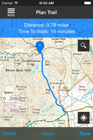
plan your own bespoke routes and measure your times for each trip. found in 1 reviews
real time location tracking via gps or wifi positioning. found in 1 reviews
continued use of gps running in the background can dramatically decrease battery life. found in 1 reviews
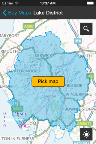
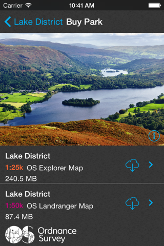
offline viewing x2013. found in 1 reviews
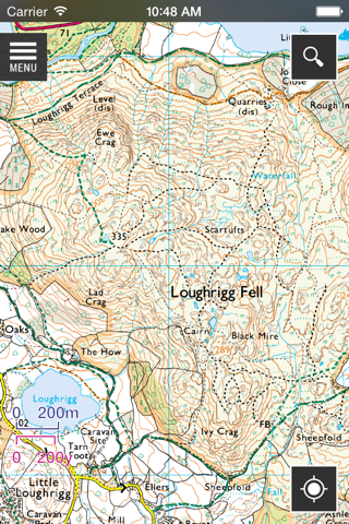
search for thousands of places across great britain in seconds. found in 1 reviews
smooth and fast zooming and scrolling between maps. found in 1 reviews
grid reference lookup. found in 1 reviews
ordnance survey is committed to creating the best mobile mapping experiences. found in 1 reviews
place name lookup x2013. found in 1 reviews
review and plan new routes from your own personal routes library. found in 1 reviews
route recording x2013. found in 1 reviews
route planning and track functionality x2013. found in 1 reviews
a free os landranger and os explorer map tile of exeter. found in 1 reviews
useful tips on how to read and navigate maps. found in 1 reviews
view current time distance speed ordnance survey grid reference latitude and longitude. found in 1 reviews
If you are iPhone and iPad owner,you now can download OS MapFinder for free from Apple Store. The application is supporting English language. It weighs in at a hefty 336 MB, so make sure you have plenty of free space on your iOS device. The new OS MapFinder app version 1.1 has been updated on 2014-11-24. The Apple Store includes a very useful feature that will check if your device and iOS version are both compatible with the app. Most iPhone and iPad are compatible. Here is the app`s compatibility information: Compatible with iPhone 3GS, iPhone 4, iPhone 4S, iPhone 5, iPod touch (3rd generation), iPod touch (4th generation), iPod touch (5th generation) and iPad. Requires iOS 5.0 or later. This app is optimized for iPhone 5.
More Info: Find more info about OS MapFinder in Ordnance Survey Limited`s Official Website : http://www.osmapfinder.co.uk
More Info: Find more info about OS MapFinder in Ordnance Survey Limited`s Official Website : http://www.osmapfinder.co.uk
iTunes Application Description OS MapFinder is the first official iPhone/iPad/iPod Touch App from Ordnance Survey, enabling users to view, navigate and download the most up-to-date OS Landranger (1:50 000) and OS Explorer (1:25 000) maps of ...
No other countries besides Britain Only Britain Timbo907
I used this app on a recent trip to England and when I didn t have cell coverage this app at least let me see where I was driving or walking I could not figure out how to use it for all functions but for free it was a good gps finder Too bad doesn t work in U S Great help Kyreader
I m really happy OS have made this app I ll be visiting my home town of Bath next week and being able to get offline OS maps on my iPhone and iPad for hiking around the outskirts of the city is really great Also having OS maps to plan with in advance is fantastic I d love to see the overall app navigation simplified as it can be a little confusing in places I think the use cases may need to be rethought a bit Also adding pins to the map would be great in addition to only routes connected by lines Also I d make this 5 stars if you implemented iCloud sync of planned and recorded routes I would like to plan routes on my iPad s big screen but take my phone with me on hikes Also I m not sure why the app is 350 megabytes Surprisingly large Excellent content Spencer E Holtaway
By far biggest issue is cost as an example my bother lives near the intersection of 4 tiles so walks we take mean buying all 4 tiles I can access Google maps for free Obviously I would prefer OS maps but for a single walk with my brother I think I ll stick with Google I d need to be doing regular walks in an unknown area to justify buying maps The other deficiency is that GPS real time data does not tell me my altitude elevation as I walk up a hill I want this also recorded to show a chart graph of my walk s cross sectional height Cost and altitude Jonathan M.C.
Thank you making it free Clean and useful JediTone
I used this app on a recent trip to England and when I didnt have cell coverage this app at least let me see where I was driving or walking I could not figure out how to use it for all functions but for free it was a good gps finder Too bad doesnt work in US Great help
Thank you making it free Clean and useful
By far biggest issue is cost as an example my bother lives near the intersection of 4 tiles so walks we take mean buying all 4 tiles I can access Google maps for free Obviously I would prefer OS maps but for a single walk with my brother I think Ill stick with Google Id need to be doing regular walks in an unknown area to justify buying maps The other deficiency is that GPS real time data does not tell me my altitudeelevation as I walk up a hill I want this also recorded to show a chartgraph of my walks crosssectional height Cost and altitude
Im really happy OS have made this app Ill be visiting my home town of Bath next week and being able to get offline OS maps on my iPhone and iPad for hiking around the outskirts of the city is really great Also having OS maps to plan with in advance is fantastic Id love to see the overall app navigation simplified as it can be a little confusing in places I think the use cases may need to be rethought a bit Also adding pins to the map would be great in addition to only routes connected by lines Also Id make this 5 stars if you implemented iCloud sync of planned and recorded routes I would like to plan routes on my iPads big screen but take my phone with me on hikes Also Im not sure why the app is 350 megabytes Surprisingly large Excellent content
By Kostas Gar.