What's New
Bug fix...
Bug fix...
Size:
Category:
Navigation
Navigation
OS:
iOS
iOS
Price:
$7.99
$7.99
Compatible:
iPhone iPad
iPhone iPad
Requirements:
Compatible with iPad.
Compatible with iPad.
Version:
1.9.2
1.9.2
Description - Topo Maps for iPad
Phil Endecott , the publisher behind many iOS app (LagerLamp ,Topo Maps for iPad ,UK Map ,Panoramascope: Augmented Reality ,Topo Maps ,Nearest Pubs), brings Topo Maps for iPad with a number of new features along with the usual bug fixes. Topo Maps for iPad app has been update to version 1.9.2 with several major changes and improvements. App release that improves performance, provides several new options.
.
If you are iPhone and iPad owner,you now can download Topo Maps for iPad for $7.99 from Apple Store. The application is supporting English language. It weighs in at only 10MB to download. The new Topo Maps for iPad app version 1.9.2 has been updated on 2014-11-18. The Apple Store includes a very useful feature that will check if your device and iOS version are both compatible with the app. Most iPhone and iPad are compatible. Here is the app`s compatibility information: Compatible with iPad. Requires iPhone OS 3.2 or later.
More Info: Find more info about Topo Maps for iPad in Phil Endecott`s Official Website : http://topomapsapp.com/
More Info: Find more info about Topo Maps for iPad in Phil Endecott`s Official Website : http://topomapsapp.com/
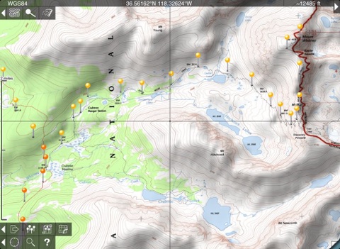
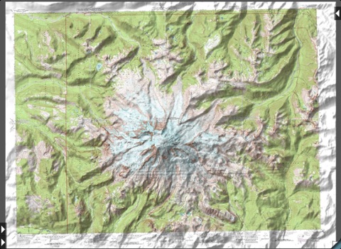
The iPad is a fantastic map viewer, and Topo Maps for iPad gives it access to over 70,000 USGS and Canadian topographical maps. Ideal for hiking and other backcountry activities. Map downloads are ...
I have been using this app on both an iPhone 4 and iPad for over a year now I have downloaded about 4000 topo maps 16 gigs worth I use it when exploring huge areas on my ATV here in Idaho Plus I downloaded 25 maps for a hog hunt in California and another 50 or so for a fishing trip to Oregon If I read about a place that sounds like I might want to explore it I download the relevant maps and check it out I have retired my Garmins This app has better maps and is easier to use with better displays It is also extremely accurate and fast To cover a single 20 mile loop could take over 50 paper maps No problem with this app I use the zoom in and out feature constantly as well as the waypoint and search feature I also use the map elevation to calibrate my Garmin GPS wrist watch frequently I use the distance ruler occasionally as well as different units capability UTM and Lat Long I rarely use the other features I usually just want to see the blue dot where I am standing and the names of the surrounding features and the waypoint marking camp My only caveats are some of the underlying maps are outdated obviously not the fault of the app Moving waypoint files between devices is a pain And downloading a maximum of 20 maps at a time is a minor inconvenience The program occasionally hangs when I launch it I haven t figured out if this is a communication problem with the Apple GPS code or a bug it the app A force abort of the app and a relaunch fixes it so it is a minor annoyance All in all this is in my top three most used and enjoyed app If you have a GPS equipped Apple device and spend time outdoors especially off the beaten track this app is spectacular Update Dec 2017 I continue to use this app extensively and love it Over the years the app has been improved in important ways For example I just upgraded to iPhoneX from my old iPhone6 Apples iTunes save restore failed to work properly Fortunately I had backed up my extensive waypoint files using that feature of this app I had to manually reload all the topo Maps into the iPhoneX but was able to reload all the waypoints from the back up file effortlessly This is really great real world functional app Fantastic App Elephant Jim
This app combined with a bluetooth Bad Elf GPS Pro works perfect on my wireless only iPad An always on option would be helpful because it currently requires the user to go to settings and change the Apple display auto lock setting to never which I seem to forget to do before I open this app then of course you have to remember to change the setting back once you stop using the app All in all though this app is highly recommended for back country driving in areas with no cellular wifi service as long as you have a GPS and have already downloaded your topo maps or offline maps I use the same app on my phone as my primary backup and hard copy maps as a second back up I do use Avenza Maps too as it offers more map options especially for kayaking but my primary back country vehicle navigation app is this one Excellent App Jamsegs
If you ever liked playing with topo maps this app is a must GREAT features allow you to measure distance and compass heading between points Awesome feature allows you to see the view shed from any point fantastic for real estate analysis I bought my mountain property based on this app Perfect balance between government provided maps and beautiful 3rd party software that makes this one of my all time favorite apps Best map app ever MaxQ 2
This is the best bargain out there I started using this app while hunting areas w o cell service Being able to download both USGS maps and satellite images for the areas ahead of time allows access to this data while offline Great App SackRoger
Dumb me I thought like with most apps I could get this and put on my iPhone as well Smart developer who made one for both devices so you have to buy it twice once for each device Great app I would give it a five star but wanted it for the phone Oh well the developer is now 8 richer so I can put it on both devices Only for iPad Lfriant
I ve been using this Ap for over a year both iPod and iPad versions with a BadElf external GPS and it works great There s no need for a cellular connection once you ve downloaded the quads you want Most recently it saved my butt while exploring a remote roadless area of Utah far from cell service Those who complain in the Ap reviews about the age quality of the maps obviously have no prior experience with USGS raster topos If you understand the limitations and advantages of those this is the best tool I ve found for using the large scale USGS quads on an affordable mobile platform My thanks to the developer for a very useful program The best App if you want USGS topos maps Catnip Gardens
Charts in most cases are very Very old Appears not to be up to date Way over priced Topo charts Great deal NOT
Great app good maps download what you need great memory saver But screen print and email is the only option for printing Add air print or email full file then app would be five stars Also w Also watch the maps they are not all current Good but not finished Ltsfytfyr
Perfect on my iPad Mini I really appreciate the ability to sync maps between my iPhone and iPad 1 15 has worked flawlessly for me Stable flexible fast responsive and well designed Of all of the apps I ve tried or bought this one stands head and shoulders above the rest I love the ability to either import or export waypoints and to share maps between my iPhone and iPad instead of needing to re download everything Still the best topo app out there update a little ticked off
I don t know if it is the new update for iOS 8 I am still using iOS 7 This app no longer does anything when opened and I can t zoom in to view maps at all No longer works Ba1234mn
Uses the older topo maps which in many cases have more detail than the newer maps If you want the most detail in your maps this is the app Works well in the field without an Internet connection because the maps are downloaded directly to your iPad beforehand Great for exploring all the little things they have left off the new maps Great for finding the little things Ron in SoCal
Its the best function to value topo mapping solution period Great job Phil Great app GSB50
I have both the iPad and iPhone versions This app is not super intuitive so read the directions There are lots of hidden capabilities For example in the map download screen tap and hold a map until it turns blue then drag to select multiple maps Also I had a problem and sent the developer an email I had a response within 24 hours Great app worth the money Great App PilotIRL
I have used the iPhone version and it is fine except of course the screen is too small The mosaic function on the iPad version which is essential to using the topo versions of the maps does not work The iPhone version works better on the iPad than the iPad version iPad version does not work EdMcClave
Poor user interface blurry maps not worth the money Very disappointing D_Snow
I ve played around a bit and I like this app The fact you can seamlessly join together maps is a big plus And then today I found that I could e mail a zipped 15x15 scale usgs map to myself and open it this app astounding Now I can have some of the usgs historical maps in the I pad I hope they don t upgrade the maps to the latest ones available A great app for USGS topo maps I miss Sunflower
I ve used it for several years both iPhone and iPad versions I have looked for something that might be as useful as the old topo maps but haven t found anything that isn t an expensive commercial solution like ESRI or the like This is a very usable way to take lots of maps with you into the field I have tried Gaia but I haven t had good luck with the download integrity This apps download routine may not be the easiest but you do have what what you somewhat tediously selected Solid and usable cshk99
For the money this should be better It needs The base map has almost no detail This makes it hard to find the topo that I really want to download and I have to guess and check with what I download I would like to know the actual file sizes before I download Just saying large or small tells me absolutely noting at all I would like to go from one map to an adjacent map without going back to the base map This is a good solid app but needs to be better Needs work but still an ok app ResevorDG
I got this app a while ago and used it occasionally The problem is it relies on the old topo maps which are hard to read US Forest service maps are way better I am trying to find those now Getting outdated nickname444
This is great app just what I was looking for I have started to do some off roading and wanted to be able to use my iPad and not my pc for the maps I have the wifi only version so I needed a off network app I tried another topo maps app that you had to have yearly or month subscription but was pain to get maps on to the iPad And when I needed to work it did not The plus side to this app is you can DL maps from with the app I give it only four stars because wish the app could track were you have been I can t seem to find away to do that Would be nice update if the app does not have it now Just what I was looking for Sir major blade
UPDATE The developer contacted me and explained that USGS has updated maps on some servers but not on the server he uses to access the GEOTiff formatted maps that the program uses He is working with them to solve the issue or find a workaround Kudos to the developer for being responsible If the maps get updated I would rate this program much higher I am keeping my fingers crossed ORIGINAL REVIEW I think the program is OK as far as the software goes but the maps are scanned versions of fairly outdated paper maps Thus you run the risk of not having roads or trails that exist on the ground not being on the map or worse roads and trails that once existed but were closed or moved not being shown on the map Had I known that the app used outdated maps I would not have purchased it As it is I am stuck with it If up to date maps are important to you look elsewhere Technically good but outdated maps Update DesertDweller06
Can I say planning camps hikes overnight camping spots has just become amazingly easy with this app Waypoints are simple linking into Google Earth from the app to look at an area or specific spot is invaluable I can evaluate a trail look at the contours measure distance and do some quick and easy advanced planning Just wish there was an easy way to print the maps with the scale and other markings on them Five star and worth it especially for Scouts miklamx
I remember buying quads for 4 each This program has the whole US for 8 Awesome deal Maps are clear on the highres setting You must download maps prior to using them Only fault is that the pindrops dont show the name unless you touch them Buy it if you are familiar with usgs quad maps Caveartist
I ve used this app for about a year and I have to say I ve been pretty pleased with it It s somewhat basic but it does what I need it to offline map storage is requirement for me and it meets that criteria easily I wish is supported a few more features like different layers such as aerial or street track recording and elevation profile generation but for the price it s hard to beat and I will continue to use it Economical Solid choice for topo Maps Sir sam79
As someone who has used USGS maps professionally for the past 40 years all I can say is I wish this app and its accompanying technology were available long ago I have this on my iPod but because of the small screen it s kind of a pain to use On the iPad or iPad mini it s better than having the actual paper map in my opinion Of course if you go to the official USGS store you can get the new orthoimage based maps but they cost 15 per quadrant If you are comfortable using traditional USGS maps this is a much much better deal In fact if you could get all the quadrants available here for under 8 total at the USGS store in orthoimage format which you can t because they don t all exist it would cost you over a million dollars Very Good Zootooz
I usually don t give comments on apps but this one is exceptional Being able to carry topos of several states and provinces wherever I go is pretty awesome Being able to look at a particular point on a topo then look at he same place in aerial view is even better Just to balance out all the praise I wish you weren t limited to 20 high res topos at once It d also be nice if you could do custom pins That s all nit picking though because it s the best topo app out there I love this app PapaGunn
I find this the biggest waste of money for any app I have ever bought The only reason I give it one star is because I could not give it zero The user interface is hard to use I was hoping to use this as a navigation aid on a hunting trip I am planning The last thing I want is to be on a mountain in Colorado with this app as my means from getting lost I think I will stick to a paper map and compass Junk Born2fish
If you need a lot of detailed topo maps and where you re going may not have cellphone signal this is the best app to have in my opinion I ve been an avid user for years If I could change a couple of things I would have a more detailed overview map a way to turn off the grid and downloaded tile highlights while looking at the overview a comment field for waypoints instead of having to type it all in the name and an easy way to upload download map tiles from the app to my computer and back again Yes some of the maps are old but I haven t had many problems with this because country areas don t change much This app in combination with the public lands app Maplet is unbeatable for off the grid trekking I will say though when this app came out there was virtually no competition but the competition has increased and they are getting better while this app really hasn t changed a lot since its release If the offline functionality is eclipsed by an app with a better overview and offline map management I would switch Best Offline Topo app Mavortium
Pros 1 Easy to figure out the interface 2 Downloads seemed quick over 3G Wifi 3 Cheaper than other apps that allow downloadable maps and or subscriptions 4 Easy to manage downloaded maps Cons 1 Super low res grid map is useless when trying to identify a map to download by geographic detail Way too blurry Thankfully you can turn on city itentification to help you figure out where you are 2 As other users have indicated the USGS maps can be ancient I KNOW this isn t the dev s fault but maybe alternate sources should be made available Both the Cabela s app and Backpacker app have much nicer maps Granted both are also more than 3x more expensive Guess you get what you pay for Ok so one could argue that even tho topo are 30 years old the maps shouldn t change that much because the geography shouldn t change that much But other references on it do change and I wouldn t want to be out there without current references Ultimately I think I ll pay the extra for the better maps I still have hope for this one though Just OK IzeUp
Talked to the developer and he claims that even if your maps crash and your pins disappear your waypoints should still be in your waypoints list So i m guessing if you download your maps again the pins will reappear UPDATE There is a setting in your phone or ipad in settings topo maps that allows you to TURN ON backing up maps The apps default setting is OFF This is why everyones maps are crashing Crashes and maps disappearing THE FIX Sharrack
The best app managing topo sheets Excellent app GoSurv
If you like and can use topo maps this is an excellent program especially if you have an usb gps so the program reads your location The one I have by Dual works fine with this program on the 1st generation ipad Without the gps capability it is not nearly as useful ancient 1 Newbie-geezer
Was having problems downloading maps so I contacted Phil he really came through for me The App Is working great now Whoops JeepRubicon
5 crashes in 5 minutes of using the app Really The waypoint management is atrocious but a great way to blow up the app 8 wasted awful christiankuhtz
I been using this app quite a bit especially when flying around It has made it very easy to flight follow along Definitely worth the 8 00 bucks I paid for it Great App Smkj94
I am a long time user of Topo Maps but I wanted to try something that had more color in their maps so I downloaded iTopoMaps I found that iTopoMaps constantly redrew as I moved the map center and just was not worth the wait Also with iTopo I never was able to down load a map section in Quinico Finally map down loads were much slower in iTopo By changing the view options I was able to get almost as good a view as iTopo finally it is a small thing but I kind of like the little waypoint icons of TopoMaps If TopoMaps reads this please consider adding a option to added connecting lines between waypoints labeled with crow flies distance Lance Stairs TopoMaps verses iTopoMaps Lstairs
I have had the worst time downloading maps keeps timing out and no customer service this app straight out is worthless i give it no stars if there was support to help and figured out if i am doing something wrong which i doubt i will retract my rating HORRIBLE kaifrog
I Am 52 and have been navigating terrain in Louisiana where I grew up hunting as well as in Texas France Belgium Germany greece and now in the Sierra Nevada mountains of California where I reside This map is so accurate that I have used it to help train a Fresno County Sheriff s Posse member on cross country horse rides in the Kaiser Wilderness and Dinkey Lakes Wilderness areas He thought I was joking until Phil Endecott s Topo app led us down a NEARLY NON EXISTANT trail directly to Ersheim lake Same posse member had his gps lose ground to this app which brought us directly to a NO NAME lake in Kaiser Wilderness while his gps was telling us to go another direction I will always carry a compass and map but this app has earned my respect and I truly enjoy being able to use long forgotten trails that this app shows to me As for why this map matches up so well with the gps I do not know why But it does Thank you Phil George Dugal Jr Excruciatingly Accurate George Dugal Jr.
I don t write many reviews But I really do think this is an excellent app We are full time 4x4 RVer s We wilderness pack back in the summer and do volunteer work for the Forest Service in the winter We prefer to disperse camp boondocking instead of staying in camp ground or RV parks This app is great for all of the things we enjoy doing I save waypoints of where we camp so we can go back to them again later I don t carry my iPad with me hiking and packing but I use this app for reference while at base camp Love the way it splices the maps together Excellent app BarbieWanders
Just got back from a fishing trip in the middle of nowhere This app got me there and back The fact you don t need Internet access to view downloaded maps makes it useful the fact it can find your location with no service makes it the most useful app I own Would recommend it to anyone I love this app Belasarius532
The maps are high resolution and look fantastic on the new iPad This app does a good job of rescaling the maps as you zoom in or out to keep them looking crisp The app is straightforward to use and allows seamless more or less stitching of maps I give it 4 5 stars only because the app stutters a little when you drag the maps around to reposition them This is probably a limitation of iPad horsepower so I maybe am a little harsh but it is a little distracting Great topo app MiguelitoBB
App authors always seem to want to squeeze more money out of us Ads on paid apps paid extra add ons you know how it goes This app has none of that You want big full resolution maps of the entire USA Sure You want low res maps to conserve space They have that too Want to see what s around you on Open StreetMaps Done See where you are with the built in GPS OK done All in all a nicely done app that does its job well Useful and non annoying NicksAreAllTaken
I can t say enough about this App Imagine having access to any Topo when you want need it along with sophisticated measuring tools GPS coordinates elevations and waypoints If you hike or bike or ride anywhere outdoors you really owe it to yourself to buy this App It s WELL worth the 8 bucks The only downside is that the USGS Topo maps are seldom up to date but that s not the fault of the App It least your far better off in the wild with such a Topo map than no map at all Any Topo map you need with amazingly useful tools hikerted
Good stitching of map is very nice simple to use doesn t get in the way of good map reading Bad old maps can t chose newer sources no way to mass delete map tiles no maps of non US Canada locations I found this app incredibly helpful really indispensable in the Sierra However it s pretty darn useless in PA and I m deleting it to save space for movies before I go to Spain Good but Ryan Sullivan
This is a very useful app and works better than the other topo apps out there People don t be stupid in your comments and ratings of this app It uses official USGS topo maps Some of them are very old yes even to 1972 and older This is NOT THE APP MAKERS FAULT Did you think one guy makes all these maps Likewise if you don t see all of your hiking trails marked Again they re government maps and not always up to date but they are great for giving you topographic features of the landscape Feel free to complain to the USGS for having old maps but remember they re the best we have I can t believe some of the ignorant uninformed comments being made Very good app 5stone23
I won t go out in the woods without a topo map and a compass With this app on my iPad or iPhone I have both I still carry the paper maps and a real compass for backup I m not going to completely trust my safety to electronics but this is what I actually use With the GPS turned on this is perfect for bush whacking and I ve used it that way on several hikes One warning the information on many topos is 50 or more years old I ve found myself trying to follow old trails and roads that are on the topo I m using but that simply don t exist on the ground not even a trace It isn t the prettiest app I own and the interface is kind of quirky but for its purpose it s almost perfect and if you use topo maps it s pretty much indispensable And as another reviewer noted it will pay for itself by the time you ve downloaded your second map Incidentally it works equally well on the iPad and the iPhone An iPad is obviously better for looking at a whole map but the iPhone is a lot easier to carry in your pocket or your hand and works just fine when you re actually finding your way around Essential Neil Faiman
This is a great app Put your 8 bucks on the line and download all the topos you can eat With my home wifi I download a quad in less than one minute And then it s on my IPad to look at any time anywhere What s not to like I could buy 2000 topos at 9 apiece to cover New Mexico and then not have the ones I need with me when I need it I tend to roam the countryside and 7 5 miles can go by pretty fast at 70mph Typos NM Pilgrim
No complaints Crystal clear image accurate no issues An essential tool for the backpacker hiker hunter fisherman or whatever else gets you into the wilderness The quads even have most hot springs labeled Excellent App Wandertale
I now own 3 of the topo maps apps on the AppStore and while this app has some nice features and interesting integration It has a clunky method for downloading and activating maps and the maps don t have enough zoom levels nor are the scans in color I want to be able to zoom in on the scans till I can count the pixels Why can t any developer get it I would like one of the map app designers to realize that nobody wants to grab quads one at a time Why can t I select an area by highlighting the 4 corners of the box on the guide map and let the app automatically batch download all the quads within that box Or better yet download a whole state at a time I have 64gb of storage why would I not want to grab a big section of maps so I don t have to use cellular later to get others I missed Import and export of waypoint datasets is awesome a feature that ITopoMaps does not have That being said it s all about the maps themselves and ITopoMaps has better color scans of the topo quads so I m staying with them Wish I had my money back on this one Buy itopomaps for better quality maps KD5JHA
I remember buying quads for 4 each This program has the whole US for 8 Awesome deal Maps are clear on the highres setting You must download maps prior to using them Only fault is that the pindrops dont show the name unless you touch them Buy it if you are familiar with usgs quad maps
The maps are high resolution and look fantastic on the new iPad This app does a good job of rescaling the maps as you zoom in or out to keep them looking crisp The app is straightforward to use and allows seamless more or less stitching of maps I give it 45 stars only because the app stutters a little when you drag the maps around to reposition them This is probably a limitation of iPad horsepower so I maybe am a little harsh but it is a little distracting Great topo app
We do some offroad exploring and camping with 4x4 vehicles in the Northwest mostly Oregon and Washington My traveling friends have a heavy duty laptop PC mounted in their truck connected to a GPS with mapping software Hoping that I could substitute my 3GWiFi iPad for the PCs I purchased this software It just plain WORKS I downloaded and installed all and I mean ALL of the high resolution maps for Oregon and Washington at no charge While this has consumed quite a bit of storage on the iPad the results are very very good With the maps installed we headed off into the heavily wooded GiffordPinchot National Forest to test the iPad and Topo Maps for IPad The iPad GPS worked just as well as my backup Garmin eTrex Legend H in terms of finding position and the application on the iPad seems to deliver most of the functionality of what my friends are getting on their PCs withe a lot less bulk in terms of equipment As we were checking this application we referred to other paper maps from time to time and soon developed complete confidence in the apps and the maps provided The only feature I find lacking at this point is a tracking feature where the app would automatically store positions as you moved along so that you could later review them as a track The best features of the app are the ability to download useful maps for free and the stitching feature that connects maps is excellent This app is easy to use reliable no problems getting to their servers no app crashes and inexpensive Great for Off Road Exploring
5 crashes in 5 minutes of using the app Really The waypoint management is atrocious but a great way to blow up the app 8 wasted awful
Its the best function to value topo mapping solution period Great job Phil Great app
Talked to the developer and he claims that even if your maps crash and your pins disappear your waypoints should still be in your waypoints list So im guessing if you download your maps again the pins will reappear UPDATE There is a setting in your phone or ipad in settings topo maps that allows you to TURN ON backing up maps The apps default setting is OFF This is why everyones maps are crashing Crashes and maps disappearing THE FIX
I wont go out in the woods without a topo map and a compass With this app on my iPad or iPhone I have both I still carry the paper maps and a real compass for backup Im not going to completely trust my safety to electronics but this is what I actually use With the GPS turned on this is perfect for bush whacking and Ive used it that way on several hikes One warning the information on many topos is 50 or more years old Ive found myself trying to follow old trails and roads that are on the topo Im using but that simply dont exist on the ground not even a trace It isnt the prettiest app I own and the interface is kind of quirky but for its purpose its almost perfect and if you use topo maps its pretty much indispensable And as another reviewer noted it will pay for itself by the time youve downloaded your second map Incidentally it works equally well on the iPad and the iPhone An iPad is obviously better for looking at a whole map but the iPhone is a lot easier to carry in your pocket or your hand and works just fine when youre actually finding your way around Essential
I usually dont give comments on apps but this one is exceptional Being able to carry topos of several states and provinces wherever I go is pretty awesome Being able to look at a particular point on a topo then look at he same place in aerial view is even better Just to balance out all the praise I wish you werent limited to 20 highres topos at once Itd also be nice if you could do custom pins Thats all nitpicking though because its the best topo app out there I love this app
A superb app for those needing 75 USGS maps The resolution is impressive navigation within the app and between maps is simple and there are a number of additional tools such as distance calculation estimated vistas waypoints map stitching and more I cant think of anything missing from this app except a feature to carry my pack for me Outstanding
Was having problems downloading maps so I contacted Phil he really came through for me The App Is working great now Whoops
I been using this app quite a bit especially when flying around It has made it very easy to flight follow along Definitely worth the 800 bucks I paid for it Great App
Pros 1 Easy to figure out the interface 2 Downloads seemed quick over 3G Wifi 3 Cheaper than other apps that allow downloadable maps andor subscriptions 4 Easy to manage downloaded maps Cons 1 Super low res grid map is useless when trying to identify a map to download by geographic detail Way too blurry Thankfully you can turn on city itentification to help you figure out where you are 2 As other users have indicated the USGS maps can be ancient I KNOW this isnt the devs fault but maybe alternate sources should be made available Both the Cabelas app and Backpacker app have much nicer maps Granted both are also more than 3x more expensive Guess you get what you pay for Ok so one could argue that even tho topo are 30 years old the maps shouldnt change that much because the geography shouldnt change that much But other references on it do change and I wouldnt want to be out there without current references Ultimately I think Ill pay the extra for the better maps I still have hope for this one though Just OK
I cant say enough about this App Imagine having access to any Topo when you wantneed it along with sophisticated measuring tools GPS coordinates elevations and waypoints If you hike or bike or ride anywhere outdoors you really owe it to yourself to buy this App Its WELL worth the 8 bucks The only downside is that the USGS Topo maps are seldom uptodate but thats not the fault of the App It least your far better off in the wild with such a Topo map than no map at all Any Topo map you need with amazingly useful tools
UPDATE The developer contacted me and explained that USGS has updated maps on some servers but not on the server he uses to access the GEOTiff formatted maps that the program uses He is working with them to solve the issue or find a workaround Kudos to the developer for being responsible If the maps get updated I would rate this program much higher I am keeping my fingers crossed ORIGINAL REVIEW I think the program is OK as far as the software goes but the maps are scanned versions of fairly outdated paper maps Thus you run the risk of not having roads or trails that exist on the ground not being on the map or worse roads and trails that once existed but were closed or moved not being shown on the map Had I known that the app used outdated maps I would not have purchased it As it is I am stuck with it If uptodate maps are important to you look elsewhere Technically good but outdated maps Update
For the money this should be better It needs The base map has almost no detail This makes it hard to find the topo that I really want to download and I have to guess and check with what I download I would like to know the actual file sizes before I download Just saying large or small tells me absolutely noting at all I would like to go from one map to an adjacent map without going back to the base map This is a good solid app but needs to be better Needs work but still an ok app
Good stitching of map is very nice simple to use doesnt get in the way of good map reading Bad old maps cant chose newer sources no way to mass delete map tiles no maps of non US Canada locations I found this app incredibly helpful really indispensable in the Sierra However its pretty darn useless in PA and Im deleting it to save space for movies before I go to Spain Good but
Just got back from a fishing trip in the middle of nowhere This app got me there and back The fact you dont need Internet access to view downloaded maps makes it usefulthe fact it can find your location with no service makes it the most useful app I own Would recommend it to anyone I love this app
If you need a lot of detailed topo maps and where youre going may not have cellphone signal this is the best app to have in my opinion Ive been an avid user for years If I could change a couple of things I would have a more detailed overview map a way to turn off the grid and downloaded tile highlights while looking at the overview a comment field for waypoints instead of having to type it all in the name and an easy way to uploaddownload map tiles from the app to my computer and back again Yes some of the maps are old but I havent had many problems with this because country areas dont change much This app in combination with the public lands app Maplet is unbeatable for off the grid trekking I will say though when this app came out there was virtually no competition but the competition has increased and they are getting better while this app really hasnt changed a lot since its release If the offline functionality is eclipsed by an app with a better overview and offline map management I would switch Best Offline Topo app
Uses the older topo maps which in many cases have more detail than the newer maps If you want the most detail in your maps this is the app Works well in the field without an Internet connection because the maps are downloaded directly to your iPad beforehand Great for exploring all the little things they have left off the new maps Great for finding the little things
I dont write many reviews But I really do think this is an excellent app We are full time 4x4 RVers We wilderness pack back in the summer and do volunteer work for the Forest Service in the winter We prefer to disperse camp boondocking instead of staying in camp ground or RV parks This app is great for all of the things we enjoy doing I save waypoints of where we camp so we can go back to them again later I dont carry my iPad with me hiking and packing but I use this app for reference while at base camp Love the way it splices the maps together Excellent app
Can I say planning camps hikes overnight camping spots has just become amazingly easy with this app Waypoints are simple linking into Google Earth from the app to look at an area or specific spot is invaluable I can evaluate a trail look at the contours measure distance and do some quick and easy advanced planning Just wish there was an easy way to print the maps with the scale and other markings on them Five star and worth it especially for Scouts
I like that you can download section and not need Internet to look at it But when you go to the big map I would like to see roads and citys Togo map
Ive played around a bit and I like this app The fact you can seamlessly join together maps is a big plus And then today I found that I could email a zipped 15x15 scale usgs map to myself and open itthis app astounding Now I can have some of the usgs historical maps in the Ipad I hope they dont upgrade the maps to the latest ones available A great app for USGS topo maps
No complaints Crystal clear image accurate no issues An essential tool for the backpacker hiker hunter fisherman or whatever else gets you into the wilderness The quads even have most hot springs labeled Excellent App
I am a long time user of Topo Maps but I wanted to try something that had more color in their maps so I downloaded iTopoMaps I found that iTopoMaps constantly redrew as I moved the map center and just was not worth the wait Also with iTopo I never was able to down load a map section in Quinico Finally map down loads were much slower in iTopo By changing the view options I was able to get almost as good a view as iTopo finally it is a small thing but I kind of like the little waypoint icons of TopoMaps If TopoMaps reads this please consider adding a option to added connecting lines between waypoints labeled with crow flies distance Lance Stairs TopoMaps verses iTopoMaps
Poor user interface blurry maps not worth the money Very disappointing
As someone who has used USGS maps professionally for the past 40 years all I can say is I wish this app and its accompanying technology were available long ago I have this on my iPod but because of the small screen its kind of a pain to use On the iPad or iPad mini its better than having the actual paper map in my opinion Of course if you go to the official USGS store you can get the new orthoimagebased maps but they cost 15 per quadrant If you are comfortable using traditional USGS maps this is a much much better deal In fact if you could get all the quadrants available here for under 8 total at the USGS store in orthoimage format which you cant because they dont all exist it would cost you over a million dollars Very Good
The best app managing topo sheets Excellent app
This app has operated great and I recommend it However if I could display tracks files the app would be more valuable and I would rate higher The maps dont show all the hiking trails and 4wheel trails so loading tracks files would be very useful for navigation Im going to still rely on a highlighted paper map or manually drop waypoints Another useful feature would be a gps bread crumb trail recorder A couple features would be a big upgrade
I have been using this app on both an iPhone 4 and iPad for over a year now I have downloaded about 4000 topo maps 16 gigs worth I use it when exploring huge areas on my ATV here in Idaho Plus I downloaded 25 maps for a hog hunt in California and another 50 or so for a fishing trip to Oregon If I read about a place that sounds like I might want to explore it I download the relevant maps and check it out I have retired my Garmins This app has better maps and is easier to use with better displays It is also extremely accurate and fast To cover a single 20 mile loop could take over 50 paper maps No problem with this app I use the zoom in and out feature constantly as well as the waypoint and search feature I also use the map elevation to calibrate my Garmin GPS wrist watch frequently I use the distance ruler occasionally as well as different units capability UTM and LatLong I rarely use the other features I usually just want to see the blue dot where I am standing and the names of the surrounding features and the waypoint marking camp My only caveats are some of the underlying maps are outdated obviously not the fault of the app Moving waypoint files between devices is a pain And downloading a maximum of 20 maps at a time is a minor inconvenience The program occasionally hangs when I launch it I havent figured out if this is a communication problem with the Apple GPS code or a bug it the app A force abort of the app and a relaunch fixes it so it is a minor annoyance All in all this is in my top three most used and enjoyed app If you have a GPS equipped Apple device and spend time outdoors especially off the beaten track this app is spectacular Fantastic App
This is a great app Put your 8 bucks on the line and download all the topos you can eat With my home wifi I download a quad in less than one minute And then its on my IPad to look at any time anywhere What s not to like I could buy 2000 topos at 9 apiece to cover New Mexico and then not have the ones I need with me when I need it I tend to roam the countryside and 75 miles can go by pretty fast at 70mph Typos
Ive used this app for about a year and I have to say Ive been pretty pleased with it Its somewhat basic but it does what I need it to offline map storage is requirement for me and it meets that criteria easily I wish is supported a few more features like different layers such as aerial or street track recording and elevation profile generation but for the price its hard to beat and I will continue to use it Economical Solid choice for topo Maps
I dont know if it is the new update for iOS 8 I am still using iOS 7 This app no longer does anything when opened and I cant zoom in to view maps at all No longer works
Perfect on my iPad Mini I really appreciate the ability to sync maps between my iPhone and iPad 115 has worked flawlessly for me Stable flexible fast responsive and welldesigned Of all of the apps Ive tried or bought this one stands head and shoulders above the rest I love the ability to either import or export waypoints and to share maps between my iPhone and iPad instead of needing to redownload everything Still the best topo app out there update
Great app good maps download what you need great memory saver But screen print and email is the only option for printing Add air print or email full file then app would be five stars Also w Also watch the maps they are not all current Good but not finished
Does a very good job at being an intermediateadvanced navigation tool Well worth the price for the maps alone The added tools make it an even better value These older maps are good as they show what was once there rather than what is there now good way to find forgotten or overgrown roads and trails They can be a pain when a road that should have been good to drive is now gone As with any tool knowing the limitations is critical Always have a backup plan and people back home who know your plan and route Thanks for the superb outdoor tool Grate app
This is great app just what I was looking for I have started to do some off roading and wanted to be able to use my iPad and not my pc for the maps I have the wifi only version so I needed a off network app I tried another topo maps app that you had to have yearly or month subscription but was pain to get maps on to the iPad And when I needed to work it did not The plus side to this app is you can DL maps from with the app I give it only four stars because wish the app could track were you have been I cant seem to find away to do that Would be nice update if the app does not have it now Just what I was looking for
I have both the iPad and iPhone versions This app is not super intuitive so read the directions There are lots of hidden capabilities For example in the map download screen tap and hold a map until it turns blue then drag to select multiple maps Also I had a problem and sent the developer an email I had a response within 24 hours Great app worth the money Great App
I got this app a while ago and used it occasionally The problem is it relies on the old topo maps which are hard to read US Forest service maps are way better I am trying to find those now Getting outdated
I have used the iPhone version and it is fine except of course the screen is too small The mosaic function on the iPad version which is essential to using the topo versions of the maps does not work The iPhone version works better on the iPad than the iPad version iPad version does not work
App authors always seem to want to squeeze more money out of us Ads on paid apps paid extra addons you know how it goes This app has none of that You want big fullresolution maps of the entire USA Sure You want low res maps to conserve space They have that too Want to see whats around you on Open StreetMaps Done See where you are with the built in GPS OK done All in all a nicely done app that does its job well Useful and nonannoying
This is a very useful app and works better than the other topo apps out there People dont be stupid in your comments and ratings of this app It uses official USGS topo maps Some of them are very old yes even to 1972 and older This is NOT THE APP MAKERS FAULT Did you think one guy makes all these maps Likewise if you dont see all of your hiking trails marked Again theyre government maps and not always up to date but they are great for giving you topographic features of the landscape Feel free to complain to the USGS for having old maps but remember theyre the best we have I cant believe some of the ignorant uninformed comments being made Very good app
I have had the worst time downloading maps keeps timing out and no customer service this app straight out is worthless i give it no stars if there was support to help and figured out if i am doing something wrong which i doubt i will retract my rating HORRIBLE
I Am 52 and have been navigating terrain in Louisiana where I grew up hunting as well as in Texas France Belgium Germany greece and nowin the Sierra Nevada mountains of California where I reside This map is so accurate that I have used it to help train a Fresno County Sheriffs Posse member on cross country horse rides in the Kaiser Wilderness and Dinkey Lakes Wilderness areas He thought I was joking until Phil Endecotts Topo app led us down a NEARLY NON EXISTANT trail directly to Ersheim lake Same posse member had his gps lose ground to this app which brought us directly to a NO NAME lake in Kaiser Wilderness while his gps was telling us to go another direction I will always carry a compass and map but this app has earned my respect and I truly enjoy being able to use long forgotten trails that this app shows to me As for why this map matches up so well with the gps I do not know why But it does Thank you Phil George Dugal Jr Excruciatingly Accurate
Ive used it for several years both iPhone and iPad versions I have looked for something that might be as useful as the old topo maps but havent found anything that isnt an expensive commercial solution like ESRI or the like This is a very usable way to take lots of maps with you into the field I have tried Gaia but I havent had good luck with the download integrity This apps download routine may not be the easiest but you do have what what you somewhat tediously selected Solid and usable
I checked out several mapping apps for the Ipad and this is by far the best for my needs I take people on scenic flights and need to identify numerous geographic features and also do some aerial fire detection and other survey work The download utility is great its easy to use and its easy to locate the proper areas to download Having the ability to download 20 maps at a time is a huge asset Ive downloaded the Idaho panhandle and Lincoln Co in NW Montana about 200 maps plus a few Canadian maps and it works excellently The waypoint marking feature and the suggested list of names based on nearby geographic features is outstanding Particularly when trying to name multiple things in the same drainage give the first one a name plus a number and the next number will pop up in the list with the same name I also really like the ability to stitch topos together just by pressing the blue arrow or if you dont want to just wait till the blue dot you progresses beyond the edge of the map and the next map will pop into view Its also easy to unstitch the maps if you need to read the Township Range markings or other info on the edge of the map Im very pleased with the app and it works fine in my airplane There is one feature Id like to see added It would be really nice to have an onscreen button that toggles a lock for the other onscreen buttons so that inadvertent touches wouldnt change the screen but would still allow the gps location to function Kudos to Phil Endecott for a great app Topo Maps for Ipad
If you like and can use topo maps this is an excellent program especially if you have an usb gps so the program reads your location The one I have by Dual works fine with this program on the 1st generation ipad Without the gps capability it is not nearly as useful ancient1
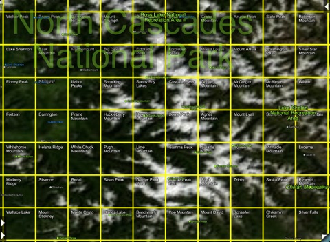
Not sure why this app gets such low ratings Where else can you get official USGS topographical maps the same exact maps you would spend a considerable amount of money to buy in the paper form And you can download them to view offline You can even download adjoining USGS maps to display seamlessly both northsouth and east west just by scrolling A simple tab in the lower right hand corner takes you to an overview of the entire continent and it clearly shows you which USGS maps you have downloaded Now you could download map by map an entire state or continent for that matter But that might be too iPad memory intensive I have however downloaded dozens of select USGS regions I am particularly interested in The app works just fine with an external Bluetooth GPS receiver the GNS since I only have an iPad with Wifi So whats not to like Now the maps you download dont seem quite as pretty or as graphically as smooth as the ones shown at the app store but they are USGS maps I know because our company keeps drawers full of the exact same maps for the entire state of Oregon The maps can be downloaded in high resolution but realize that the maps are scans so complaints about the look need to be tempered Now the map graphic enhancements in settings such as shading etc dont really enhance that much in my view But one has to realize that the more topographic features that are present the better the map look A USGS map is not designed for presenting pretty images of streets and roads in cities with flattened topography And yes there are other mapping apps that are perhaps prettier But you know what They are probably based on the original USGS maps that are presented here A USGS map is about topographic detail not finding your way to a Starbucks So if I want to be star stingy I guess I could subtract one for the graphic enhancements in settings But in a way thats not quite fair because the app delivers in providing actual USGS maps within a relatively fluid interface You just tab to the overview press and hold on a map you have previously downloaded and it opens The app has other useful features like a button that provides a circular mileage and degrees overlay With your finger you can rotate the degrees to indicate direction of travel or just to see what the declination might be with respect to geographic north While I may not be taking the iPad directly into the field archaeology it certainly travels in the car and I prefer these maps to any others for the orientation detail They are the industry standard for many professions USGS Maps
I find this the biggest waste of money for any app I have ever bought The only reason I give it one star is because I could not give it zero The user interface is hard to use I was hoping to use this as a navigation aid on a hunting trip I am planning The last thing I want is to be on a mountain in Colorado with this app as my means from getting lost I think I will stick to a paper map and compass Junk
I now own 3 of the topo maps apps on the AppStore and while this app has some nice features and interesting integration It has a clunky method for downloading and activating maps and the maps dont have enough zoom levels nor are the scans in color I want to be able to zoom in on the scans till I can count the pixels Why cant any developer get it I would like one of the map app designers to realize that nobody wants to grab quads one at a time Why cant I select an area by highlighting the 4 corners of the box on the guide map and let the app automatically batch download all the quads within that box Or better yet download a whole state at a time I have 64gb of storage why would I not want to grab a big section of maps so I dont have to use cellular later to get others I missed Import and export of waypoint datasets is awesome a feature that ITopoMaps does not have That being said its all about the maps themselves and ITopoMaps has better color scans of the topo quads so Im staying with them Wish I had my money back on this one Buy itopomaps for better quality maps
By Kostas Gar.