What's New
Bug fix...
Bug fix...
Size:
Category:
Navigation
Navigation
OS:
iOS
iOS
Price:
$5.99
$5.99
Compatible:
iPhone iPad
iPhone iPad
Requirements:
Compatible with iPhone
Compatible with iPhone
Version:
1.0.3
1.0.3
Description - Marine US
.
It tracks your location beautifully as advertised on NOAA charts. found in 3 reviews
to be able to navigate at 40 mph at times. found in 1 reviews
I use it as a backup on my boat. found in 1 reviews
Not up to the website version yet. found in 1 reviews
Awesome alternative to paper charts. found in 1 reviews
Great app in the Fl Keys. found in 1 reviews
very useful and handy for boating. found in 1 reviews
Can't figure out how to delete waypoints. found in 1 reviews
It does not measure a route distance. found in 1 reviews
Dropbox integration would be a plus. found in 1 reviews
Decent App but could be better. found in 1 reviews
and does not show a satellite view. found in 1 reviews
Would've given 2 stars but the low price makes it 3. found in 1 reviews
That issue went away when I zoomed out more. found in 1 reviews
Problems don't start to show their full glory at first. found in 1 reviews
Nothing like the sales pitch. found in 1 reviews
Fairly useless. found in 2 reviews
If you are iPhone and iPad owner,you now can download Marine US for $5.99 from Apple Store. The application is designed for use in English language. It weighs in at only 10MB to download. The new Marine US app version 1.0.3 has been updated on 2014-11-18. The Apple Store includes a very useful feature that will check if your device and iOS version are both compatible with the app. Most iPhone and iPad are compatible. Here is the app`s compatibility information: Compatible with iPhone, iPod touch, and iPad. Requires iPhone OS 3.0 or later.
Bottom Line: For more information about Marine US check developer GeoGarage`s website : http://marine.geogarage.com/mobile
Bottom Line: For more information about Marine US check developer GeoGarage`s website : http://marine.geogarage.com/mobile
Marine US is an iPhone/iPad universal application which gives you access to all the catalogue of nautical raster charts for USA (from NOAA Hydrographic Service material) This is the alter ego app for sailing of the ...
Long Island sound and Chesapeake Great maps of east coast waterways Asian Jesus
It sure doesn t look like a nautical chart any longer Very disappointed iOS 9 0 1 has ruined this app Whi8464
Only pacific still working Atlantic totally gone Was great wonder if they will fix it No good after ios9 upgrade Deck orangutan
After ios9 upgrade the NOAA maps won t show It only shows the ground level maps on both my iPhone and iPad Before it worked great No good after ios9 upgrade Superstevep
This app is not really that useful Marine Charts by EarthNC is far better for route planning and can import and export routes in standard GPX format Fairly useless InchigeelaMan
This app is not really that useful Marine Charts by EarthNC is far better for route planning and can import and export routes in standard GPX format Fairly useless InchigeelaMan
Purchased for depth info on Florida Bay that isn t available on the map Returning due to this No info on Florida Bay Fisher772
Just bought this to find the latest buoy locations in Moriches Bay Long Island NY following explicit instructions for passage from TowBoat US This app has old NOAA charts that do not show the new buoy locations Charts not up to date Easy St.
Is there anyway you can add a route function Or at least be able to know the lat long and course of the waypoints Basically add the capability of the desktop program that the Producers have duplicated to the app All you can do is view the chart and drop a waypoint But there is zero amplifying information Great start Fast boats
Not sure if I didn t read the description right or what but it s just charts no GPS I ll keep it for the charts but I ll still need something more to position myself for fishing Meh Skippykickass
Love it Excellente Lost in the sea
Was needing to see the bottom and I can now Is there a mechanism to read lat Lon that I can t find Drop a waypoint and read off lat Lon Some way to get hold of developers I am running a 14 skiff around wrangell island I use this to see depths for halibut fishing Works for me LoggersWorld
Good app for the price but now needs to be updated to the new iPad operating system The OS upgrade now does not allow for your location to be found on the chart Capt Boswain
Would ve given 2 stars but the low price makes it 3 Extremely basic If u go to an area or zoom level that u did not view while connected u can t use it while offline Wish it would let u explicitly download an area Can t figure out how to delete waypoints Only things I can do are view my current location and add a waypoint with no notes or details There is no other functionality that I can find Does show actual buoy marker numbers tho which is better detail than the basic maps that come with a 600 Humminbird GPS Works ok for the price but very basic Lignss
Nice images but no interface at all not even the basics Draws pretty pix that s it Steven Limbert
it would be great to have the ability to save the traveled route along with date and time at user configurable intervals Dropbox integration would be a plus The ability to overlay historical data on google maps would be an even bigger plus Great app but Jfraser95
Your buying a picture A lousy non informative picture Horrible Krisit22
First of all this looks great Had it on the bay today and really like the way charts show up on my iPad However I have click on the little icon on the lower left to locate my boat and cannot get it to appear Any help most appreciated I am excited to use this again Question Mike's Tips
We bought this app for our iPad 2 that was strapped onto the handlebars of our jet ski with the waterproof Lifedge case to be able to navigate at 40 mph at times We installed it and used it immediately on a 9 day jet ski journey on Chesapeake Bay in late July I would give this app a 4 5 stars It worked very well 95 of the time and the other time it had some issues with errors tile not able to load for some of the tiles That issue went away when I zoomed out more but it did happen occasionally It tracks your location beautifully as advertised on NOAA charts I was able to chart out a route and follow it in fairly rough seas for jet skis by heading to the next flag on the route It does not measure a route distance but will measure from your location to a waypoint easily It also does not show any services like marinas towns restaurants etc and does not show a satellite view but for 6 was pretty amazing and did exactly what we needed in our first time in Chesapeake Bay doing a 200 mile loop from Havre de Grace down to Cambridge Md and back Nice app Chesapeake Bay OK TimmyVan
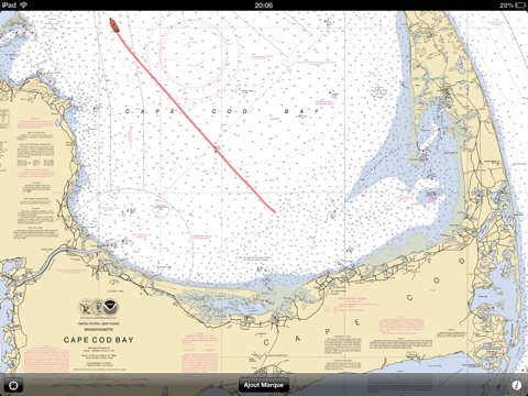
I bought this app on the advice of a friend after my helm mounted gps crapped out They showed cape cod bay in the preview for the app and thats exactly where i do most of my boating So for the 6 bucks i said what the hell Easy to use Im used to using a more permanaent unit so the lack of a curser bugged me a bit Im very familiar with the waters i boat in and think it will be ok if i get fogged in or at night Hey for 6 bucks beats buying a new gps unit for 600 So far so good Arch bishops enema fetish
Well done Aerogolfer Gone 2
My husband and I used this app to navigate off the Florida Keys It worked great and was quite accurate with location on snorkeling and fishing spots Great app in the Fl Keys Listentothewords
Excellent app very useful and handy for boating Access to charts is fast and seeing your boat s track makes it a breeze to use Very well done Outstanding jpbreeze
Don t make the mistake I did Once I see this review is posted it will be deleted Problems don t start to show their full glory at first Shameful Waste of money Procyon256
The trackiing app is nice However future improvements should include 1 ability to name rename waypoints 2 if you exit the application because your iphone timeout and requires your pass code the track disappears This was especially frustrating when you are trying to troll the same spot and retracing your routes The app should be able to run in the background and continue to store your track 3 ability to save your track and routes does not exist 4 ability to see how many miles from your starting point or a waypoint to your current location does not exist 5 the knot indicator in the top left of the screen is too small it should be big and centered on the bottom of the map I look forward to future releases and I truly believe this app can be better with the changes mentioned above Is it worth 5 99 No This is an app that should ve costed no more than 0 99 based on the functionality Decent App but could be better Madrass
Don t waste your money Nothing like the sales pitch Waste of money captart
Let s face it Most of us have gps these days anyway This is a great way to plan a course without dragging out the huge charts Not for long sailing trips but perfect for the day trips around the Chesapeake Well worth the 5 99 Great app Media_arteest
Good as most of the 30 dollar sea nav aps that are out there Thanks Great app Jaytampa
This is a great application It gives me detailed NOAA charts at any scale of any location I use it to study a route and plot waypoints before I take a trip I use it as a backup on my boat I use it so passengers can see where we are and where we re headed without messing with oversized paper charts or crowding me at the helm I have the Furuno Navnet 3D on my boat as state of the art as you can get in navigation Sure it can do a lot more But for 5 99 compared with 8 000 for the Furuno Marine US is one heck of a wingman Awesome alternative to paper charts Seadog 2010
Not up to the website version yet But a great start Great start E@Epstein.net1
This app is exactly what it says a compilation of charts Unfortunately the charts they chose for the Florida Keys have almost NO information making this virtually useless for me If you boat in an area with good charts most ANYWHERE else from what I can tell it d be great Great for most just not in the Keys Lost in keys
it would be great to have the ability to save the traveled route along with date and time at userconfigurable intervals Dropbox integration would be a plus The ability to overlay historical data on google maps would be an even bigger plus Great app but
Love it Excellente
My husband and I used this app to navigate off the Florida Keys It worked great and was quite accurate with location on snorkeling and fishing spots Great app in the Fl Keys
Your buying a picture A lousy noninformative picture Horrible
Not up to the website version yet But a great start Great start
This is a great application It gives me detailed NOAA charts at any scale of any location I use it to study a route and plot waypoints before I take a trip I use it as a backup on my boat I use it so passengers can see where we are and where were headed without messing with oversized paper charts or crowding me at the helm I have the Furuno Navnet 3D on my boat as stateoftheart as you can get in navigation Sure it can do a lot more But for 599 compared with 8000 for the Furuno Marine US is one heck of a wingman Awesome alternative to paper charts
I bought this app on the advice of a friend after my helm mounted gps crapped out They showed cape cod bay in the preview for the app and thats exactly where i do most of my boating So for the 6 bucks i said what the hell Easy to use Im used to using a more permanaent unit so the lack of a curser bugged me a bit Im very familiar with the waters i boat in and think it will be ok if i get fogged in or at night Hey for 6 bucks beats buying a new gps unit for 600 So far so good
Excellent app very useful and handy for boating Access to charts is fast and seeing your boats track makes it a breeze to use Very well done Outstanding
Good as most of the 30 dollar sea nav aps that are out there Thanks Great app
Lets face it Most of us have gps these days anyway This is a great way to plan a course without dragging out the huge charts Not for long sailing trips but perfect for the day trips around the Chesapeake Well worth the 599 Great app
The trackiing app is nice However future improvements should include 1 ability to namerename waypoints 2 if you exit the application because your iphone timeout and requires your pass code the track disappears This was especially frustrating when you are trying to troll the same spot and retracing your routes The app should be able to run in the background and continue to store your track 3 ability to save your track and routes does not exist 4ability to see how many miles from your starting point or a waypoint to your current location does not exist 5the knot indicator in the top left of the screen is too small it should be big and centered on the bottom of the map I look forward to future releases and I truly believe this app can be better with the changes mentioned above Is it worth 599 No This is an app that shouldve costed no more than 099 based on the functionality Decent App but could be better
Dont waste your money Nothing like the sales pitch Waste of money
This app is not really that useful Marine Charts by EarthNC is far better for route planning and can import and export routes in standard GPX format Fairly useless
Wouldve given 2 stars but the low price makes it 3 Extremely basic If u go to an area or zoom level that u did not view while connected u cant use it while offline Wish it would let u explicitly download an area Cant figure out how to delete waypoints Only things I can do are view my current location and add a waypoint with no notes or details There is no other functionality that I can find Does show actual buoy marker numbers tho which is better detail than the basic maps that come with a 600 Humminbird GPS Works ok for the price but very basic
Nice images but no interface at all not even the basics Draws pretty pix thats it
Is there anyway you can add a route function Or at least be able to know the latlong and course of the waypoints Basically add the capability of the desktop program that the Producers have duplicated to the app All you can do is view the chart and drop a waypoint But there is zero amplifying information Great start
Purchased for depth info on Florida Bay that isnt available on the map Returning due to this No info on Florida Bay
Just bought this to find the latest buoy locations in Moriches Bay Long Island NY following explicit instructions for passage from TowBoat US This app has old NOAA charts that do not show the new buoy locations Charts not up to date
Not sure if I didnt read the description right or what but its just charts no GPS Ill keep it for the charts but Ill still need something more to position myself for fishing Meh
This app is exactly what it says a compilation of charts Unfortunately the charts they chose for the Florida Keys have almost NO information making this virtually useless for me If you boat in an area with good charts most ANYWHERE else from what I can tell itd be great Great for most just not in the Keys
First of all this looks great Had it on the bay today and really like the way charts show up on my iPad However I have click on the little icon on the lower left to locate my boat and cannot get it to appear Any help most appreciated I am excited to use this again Question
Good app for the price but now needs to be updated to the new iPad operating system The OS upgrade now does not allow for your location to be found on the chart Capt
Well done Aerogolfer
We bought this app for our iPad 2 that was strapped onto the handlebars of our jet ski with the waterproof Lifedge case to be able to navigate at 40 mph at times We installed it and used it immediately on a 9 day jet ski journey on Chesapeake Bay in late July I would give this app a 45 stars It worked very well 95 of the time and the other time it had some issues with errors tile not able to load for some of the tiles That issue went away when I zoomed out more but it did happen occasionally It tracks your location beautifully as advertised on NOAA charts I was able to chart out a route and follow it in fairly rough seas for jet skis by heading to the next flag on the route It does not measure a route distance but will measure from your location to a waypoint easily It also does not show any services like marinas towns restaurants etc and does not show a satellite view but for 6 was pretty amazing and did exactly what we needed in our first time in Chesapeake Bay doing a 200 mile loop from Havre de Grace down to Cambridge Md and back Nice app Chesapeake Bay OK
Dont make the mistake I did Once I see this review is posted it will be deleted Problems dont start to show their full glory at first Shameful Waste of money
Was needing to see the bottom and I can now Is there a mechanism to read lat Lon that I cant find Drop a waypoint and read off lat Lon Some way to get hold of developers I am running a 14 skiff around wrangell island I use this to see depths for halibut fishing Works for me
By Kostas Gar.